Trimble SiteVision System Overview
Trimble® SiteVision™ is a high accuracy augmented reality system that is ideal for use outdoors. It enables you to interact with your spatial data in the context of the real world. You can visualize and measure positions using GNSS and Augmented Reality technology as you explore the project site.
The SiteVision app is supported on a number of Trimble devices powered by the Windows 10 operating system connected to a Trimble GNSS receiver, and on BYO devices powered by the Android™ operating system version 9.0 and later. This guide covers using the system on
The SiteVision system is an integrated positioning solution that works with GNSS and a device's camera. It requires:
- the SiteVision app running on one of the following Trimble devices, powered by the Windows 10 operating system:
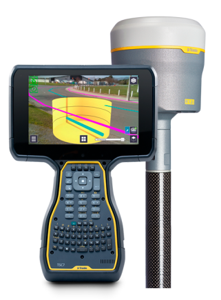
- Trimble TSC7 controller / Trimble Ranger® 7 data collector / Spectra® Geospatial Ranger 7 data collector
- Trimble T7 tablet / Trimble Yuma® 7 tablet computer
- one of the following Trimble GNSS receivers, with tilt sensor technology, connected to the device via Bluetooth® technology:
- Trimble R12i GNSS receiver
- Trimble SPS986 GNSS Smart Antenna
To begin to use the system you will need a model that you want to visualize. The SiteVision system supports a wide range of model types including models of houses, commercial buildings, road designs, site designs, landscape plans, and utility services. It also supports the visualization of 2D data from GIS systems.
The models can be created with a range of Trimble applications or many third party packages such as AutoCAD and ArcGIS.
Before you start you will need:
- One of the Trimble devices listed above, connected to one of the GNSS receivers listed above, and properly configured.
- The SiteVision app downloaded to the device
- A Trimble Identity to be able to log into the SiteVision app
- A current SiteVision subscription
- A model to view. Alternatively, you can create a model in the field.
To use the SiteVision system you will need a Trimble Identity.
- If you have an existing Trimble ID you will be able to use it for all SiteVision related services.
- If you are a new Trimble user, go to the
The Trimble ID allows you to log into the SiteVision system and Trimble Connect with the same username and password.
Contact your Trimble distributor to purchase a subscription to the SiteVision services. When you contact your distributor you will need to provide the email address that you use for your Trimble ID. Your distributor will assign the license to your Trimble ID.
Then proceed to install the SiteVision app from Trimble Installation Manager.