Using the Measure Cut/Fill app 
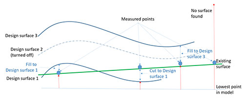
Measure Cut/Fill records the difference between the existing ground surface and the design surface, as a virtual stake.
-
Red - Indicates a cut.
-
Blue - Indicates a fill.
Cut/Fill measurements can be taken with:
-
GNSS
 , for best accuracy. The accuracy with GNSS measurements is a few centimeters.
 -
EDM
 , often quick and convenient for a number of measurements. The accuracy of the cut/fill with the EDM depends on the accuracy of the tilt sensors in your device, which vary by device model. When used in conjunction with a high precision RTK Fixed GNSS position, typical accuracies of +/- 10 cm (4 in) can be achieved for points at short ranges (5-10 m / 15-30 ft).
 -
LiDAR
 or Camera
  .
.
TIPS –
-
In the Cut/Fill Details window, you can delete a cut/fill measurement; tap
 in the bottom right corner of the window.
 -
Cut/Fill measurement will return valid values only when there are design surfaces above or below the point.
-
If you have multiple surfaces loaded in SiteVision, use Layers to manage which surface is measured to. SiteVision will measure to the lowest design surface that is visible (turned on). See Viewing a Model for more information on Layers.