Trimble SiteVision System Overview
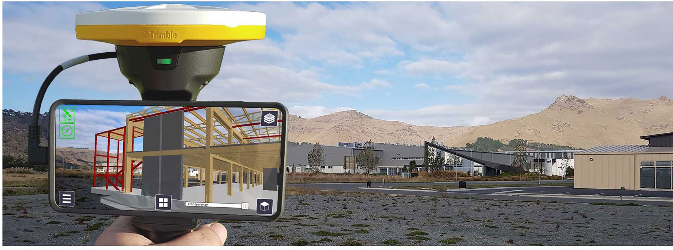
Trimble® SiteVision® is a high accuracy augmented reality system that is ideal for use outdoors.
A lightweight handheld positioning solution, SiteVision works with the Google® Play Services for AR technology or the Apple® ARKit® technology and enables you to interact with your spatial data in the context of the real world. You can visualize and measure positions using GNSS, Electronic Distance Measurement, LiDAR (supported devices only), and Augmented Reality technology as you explore the project site.
The SiteVision system includes:
-
the SiteVision app, which is supported on a user-supplied device which meets the following:
-
a device powered by iOS 13 and later, from iPhone® 6s and later, or iPad® (2017) and later, that is supported by the Apple ARKit technology
-
a device powered by the Android™ operating system version 9.0 and later, that is supported by the Google AR technology
-
-
support for two different hardware configurations:
-
mounted on a survey pole or extension rod with a standalone Trimble DA2 GNSS receiver. This is supported on Android and iOS devices.
-
the handheld SiteVision Integrated Positioning System. This is supported on Android devices only.
The SiteVision Integrated Positioning System integrates the Trimble DA1 GNSS antenna with Electronic Distance Measurement (EDM) technology and a power management system that provides power to the DA1 GNSS antenna, the EDM, and your device running the SiteVision app. See Setting up the SiteVision Integrated Positioning System for more information.
-
-
Trimble positioning and correction services (Trimble Catalyst™ GNSS technology)
-
cloud services (Trimble Connect)
To begin to use the system you will need a model that you want to visualize.
NOTE – A sample model is included when you install the app, so that you can explore the app's features.
The system supports a wide range of model types including models of houses, commercial buildings, road designs, site designs, landscape plans, and utility services. It also supports the visualization of data from GIS systems.
The models can be created with a range of Trimble applications or many third party packages such as AutoCAD and ArcGIS.
Before you start you will need:
-
A device which meets the following:
-
powered by Android 9.0 or later that is supported by the Google AR technology
-
powered by iOS 13 and later, from iPhone 6s and later and iPad (2017) and later, that is supported by the Apple ARKit technology
-
-
The app downloaded to the device
-
A Trimble Identity to be able to log in to the app
-
A current subscription
-
A model to view. Alternatively, you can create a model in the field or use the sample model included when you install the app.
To use the SiteVision system you will need a Trimble Identity to log into SiteVision, Trimble Connect, or any other Trimble system.
-
If you have an existing Trimble ID you will be able to use it for all SiteVision related services.
-
If you are a new Trimble user, go to the Trimble ID signup page to create a Trimble ID.
The Trimble ID allows you to log into the SiteVision system and Trimble Connect with the same username and password.
If you want to delete your Trimble ID account, go to Menu / Tools / About / Account. You will be redirected to your My Trimble account page, where you can delete your account.
Contact your Trimble distributor or Trimble sales representative to purchase a subscription to the SiteVision services. When you contact your distributor you will need to provide the email address that you use for your Trimble ID. Your distributor will assign the license to your Trimble ID.
Then proceed to download the SiteVision app from the Google Play Store or Apple App Store.
-
Go to the Google Play Store or Apple App Store and search for Trimble SiteVision.
-
Download and install the app.
-
Run the Trimble SiteVision app on your device.
-
To get started, accept the End User License Agreement and then enter your Trimble ID username and password.
Trimble Connect is a cloud-based data management and collaboration platform that allows you to view, share, and access project information over the internet from anywhere at any time. Trimble Connect stores the 2D and 3D models, prepared in your office software, that are to be viewed in SiteVision.
The subscription for Trimble Connect is included with your SiteVision subscription. If you have separate users who will only be doing data preparation you can purchase separate standalone subscriptions for just Trimble Connect for them.
To get started with Trimble Connect, go to the Trimble Connect website.
Trimble Catalyst is a GNSS receiver completely implemented in software (softGNSS receiver). Trimble Catalyst technology is used by SiteVision to obtain high accuracy GNSS positions on your mobile device.
A Trimble SiteVision subscription includes a Trimble Catalyst for SiteVision Subscription, which includes the precision accuracy level for use with the SiteVision app, access to Trimble Corrections Hub, including Trimble VRS Now™ networks and Trimble RTX® technology globally, and also supports GNSS corrections from other third party sources. To learn more about Trimble Catalyst, go to the Trimble Catalyst website.
Google and Apple have developed services for building augmented reality experiences. The service enables your mobile device to sense its environment, understand the world and interact with information.
To learn more about Google AR technology, go to the Google ARCore website.
To learn more about Apple ARKit technology, go to the Apple AR website.