

The Evolution of Augmented Reality
Five years ago Trimble brought augmented reality to the 2017 ConExpo event: accurate to the centimeter level, it was one of the first steps along the path of applying augmented reality to the spatial and construction industries.
Like a science fiction movie, the ability to click your fingers and see your 3D model of a road, a jobsite, or the pipes beneath the ground was what pulled people to augmented reality (AR); the ability to see a paper PDF design projected on the ground or a 3D computer model in the real world means that all involved parties are on the same page. From clients through engineers to contractors and machine operators, AR allows everyone involved in the project to see the common goal, from the start of the project to the end (and everything in between).
![]()
With this in mind Trimble embarked on a journey, working alongside input from global customers, to release the Trimble SiteVision outdoor AR system in 2019: a system combining a lightweight GNSS receiver with a mobile app that allows users to accurately visualize spatially located data through their phone camera. It is the universal AR solution for users; it doesn’t matter if you are a civil engineer, a GIS technician, or an architect, SiteVision is able to visualize your data from emailed PDF’s to live GIS feature services, to design data living on Trimble’s Connect cloud based platform. Alongside being able to see your data in context, you can also interact with it: SiteVision has a range of tools that allows you to measure between your AR model and real world locations using GNSS and remote positioning.
Today there are thousands of users of the Trimble SiteVision system across the Geospatial and Construction industries, collecting data, inspecting, and collaborating using AR. The initial solution was universal, flexible, and most importantly, successful. So Trimble moved onto the next step in the evolution of AR: industry specific AR applications.
How does a surveyor use AR? Can a civil construction job site incorporate AR? How can a builder use AR?
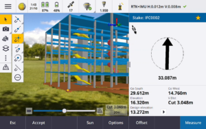
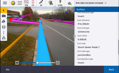
For surveyors, AR was integrated into Trimble’s leading survey application: Trimble Access. With the latest IMU-based tilt compensation receivers (the R12i) Trimble Access users are now able to view and use their data in AR. This means rather than having a client squinting at a map on a computer to see a boundary line, they can walk outside alongside the surveyor and see exactly where that property line is. Alongside that, a surveyor can pull data directly from web feature services to visualize underground services, see structures for planning or inspection purposes in real life, and stake out from computed points to objects in BIM models, all through the power of AR.
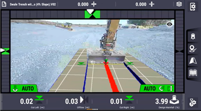
For machine operators, Trimble Earthworks now supports AR views. You can sit in the cab of an excavator, and see your cut/fill requirements highlighted in the real world, without compromising the safety of being able to see the site, the people and machines around you. Whether cutting a pad, digging a trench or trimming a side slope, the AR view lets you see and understand the design in context.
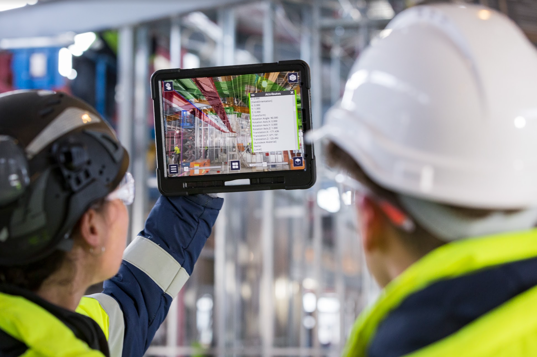
In the world of building construction, SiteVision was taken indoors and transformed into Trimble Connect AR: again, a mobile app that allowed you to visualize and interact with your data, but without the GNSS positioning requirements. Instead, LiDAR, QR code placements and BIM expertise bring the data out of the job trailer and into the field. Thus, Trimble enables collaboration, data visualization and inspection capabilities during fabrication and construction.
Whilst Trimble moved into industry specific applications of AR, SiteVision also continued to grow as our universal solution. Initially starting as an Android™ mobile app alongside an integrated antenna hardware solution, it grew to include iOS devices, incorporating the LiDAR capabilities found on the latest iPhone & iPad Pros. By integrating LiDAR into our measuring capabilities, the need for a specific hardware solution faded: the hardware cost for an AR solution is now limited to Trimble’s latest lightweight GNSS receiver, the DA2, and the user’s choice of a handheld pole or a range pole for outdoor centimeter accuracy.
 Looking to the future, the growing development and use of tools like Trimble Quadri allow customers to create a digital twin of their real world environment; SiteVision then allows you to visualize that digital twin in the real world, and utilize the information from the model whilst working in the real world, in real time.
It’s been 5 years since Trimble’s initial step into augmented reality. SiteVision continues to grow and evolve, with augmented reality solutions that are accurate to the centimeter level outside, and inside. As augmented reality continues to merge the physical and digital worlds, the question to ask now is: what problems can Trimble’s AR solutions solve for you?
More Trimble SiteVision
Subscribe to the Trimble SiteVision blog so you'll be alerted with the latest posts.