

What’s New with Trimble SiteVision?
The Trimble SiteVision team is pleased to announce that version 1.10 of Trimble SiteVision Software is now available!
Trimble SiteVision v1.10 was released on Google Play Store on January 22nd, 2020. In this release, we have introduced several new features for better workflows in the field, as well as new tools to help with data preparation.
Click here to view plans and pricing, and to find your Authorized Trimble Distributor.
Summary of new features:
- Ability to use SiteVision without Internet Connectivity
- Placing Pit View with the integrated Electronic Distance Measurement (EDM)
- Trimble SiteVision Visualization Manager
- Expanded Coordinate System Support
- Viewing Point Names, Attributes, and Location in 2D View
- Updates to User Interface and Gestures
- Workflow improvements to Measured Placement
New Features
Ability to use SiteVision without Internet Connectivity
If you work in areas with limited to no cellular coverage you can now log in and use SiteVision – with some prior preparation.
Before going to the field, or while you are still in an area of internet connectivity, you can download your models from Trimble Connect via the SiteVision application, and store them on your mobile phone. Then, when you are on-site, you can load and visualize your models via the “on device” workflow.
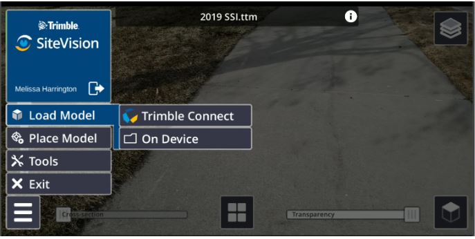
The new “On Device” menu option for loading models for visualization in SiteVision
To obtain GNSS corrections onsite you will need to select Trimble Corrections Hub under your GNSS Configuration. If you are not connected to the internet or a WiFi correction source, you will then start receiving GNSS corrections via satellite (Trimble RTX via Satellite) and your positional accuracy will improve over time to 10-30cm or better.
Note: Trimble SiteVision subscriptions include worldwide and configuration-free access to Trimble correction services through the Trimble Corrections Hub (TCH). TCH dynamically selects the appropriate correction service based on the environment and availability. To view detailed VRS Now and RTX Coverage maps click here.
This new workflow will also benefit those who work in areas with internet connectivity. You can now download models to your mobile phone from your office WiFi in advance, saving your cellular data usage. You’ll also see better performance, with a faster model loading time of the model in SiteVision.
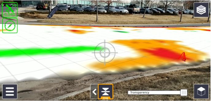
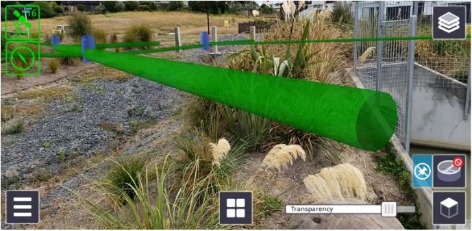
Placing Pit View using EDM
We highlighted the value of the Trimble SiteVision Integrated Positioning System in Part 2 of our Why Understanding Accuracy Is Important blog series.
In the latest release of SiteVision the inbuilt Electronic Distance Measurement (EDM) is used for placing the top of the Pit View accurately at ground level. This is of benefit particularly if the ground is sloping because the Pit view will follow the terrain as you look up/downhill. The accurate placement of Pit View enables you to obtain more accurate depth information in the Pit, in relation to the real-world ground surface. If the EDM is not available, or if it is unable to obtain a measurement, the Pit will be placed 1.5m below the device.
Placement of Pit via the integrated EDM on the Trimble SiteVision Integrated Positioning System. This is identified by the orange outline and “EDM” on the Pit View icon.
Trimble SiteVision Visualization Manager
The Trimble SiteVision Visualization Manager is a new Windows Desktop application and a complementary tool that can be used as part of the data preparation process for the Trimble SiteVision application. The tool generates user-defined content for improved visualization and management of data in SiteVision.
The Visualization Manager is ideal for use with GIS and utilities data (SHP, GDB, TMAPS) but other functionalities such as attribute and layer management are useful for users of other supported data formats such as IFC.
From within SiteVision Visualization Manager you can assign shapes, symbols, and colours to certain components of your data. For example, a simple, white, 2D line called “Stormwater” can be converted into a 3D pipe of the correct diameter, and color. If the data contains a lot of information such as attributes or layers, the user can also use the tool to manage layers (turn them on and off), as well as organizing attributes for better viewing in SiteVision.
Utilities model without rules and symbology applied
Utilities model with rules and symbology applied: Colors, depth, and diameter.
To download the Trimble SiteVision Visualization Manager go to the Trimble SiteVision Support page and under Popular Links you will find the Trimble SiteVision Visualization Manager.
Expanded Coordinate System Support and Management of Geoids
For those who prefer the automatic placement workflow with SiteVision, we have introduced an automatic update of the Coordinate System Definition, downloaded as part of the SiteVision application. This means that whenever Trimble releases a new Coordinate System Definition, your Trimble SiteVision system will also be up to date with the latest coordinate systems available in your Trimble office and field software solutions.
This release has also incorporated updated error messages for unsupported or missing geoid files, as well as an improved display of model information accessed by selecting the “i” beside the model name when the menu is open.
Viewing Point Names, Attributes and Location in 2D View
When using 2D view, it is now possible to view model attributes and display control point names. We have also introduced the ability to view your current location in 2D, which is useful for understanding your location and orientation relative to the overall data.
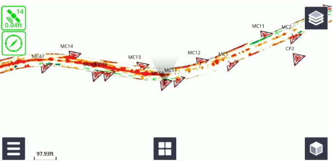
Viewing control point names in 2D View
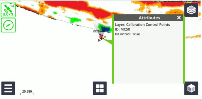
Viewing control point attributes, and understanding your current location and orientation in 2D View.
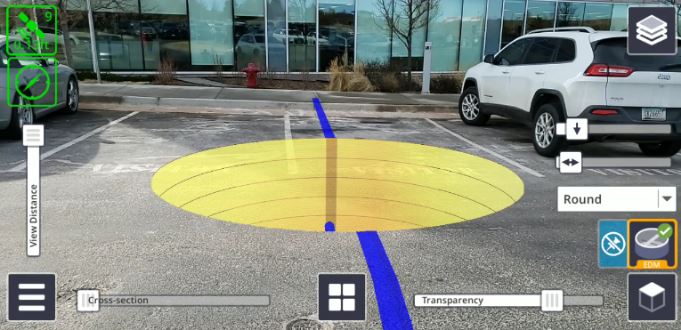
Updates to User Interface and Gestures
We have introduced a new look for our measurement modes (GNSS, EDM and AR), as well as a new icon and gestures for Manual Placement. When using Manual placement you now have the option to twist, pinch and zoom, and zoom extents.
Example of new interface for measurement modes: Cut/Fill Measurement with EDM.
New Manual Placement icon in place of GNSS icon.
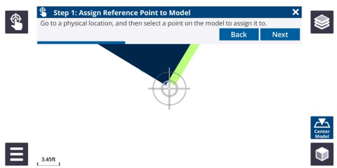
Workflow Improvements to Measured Placement
We have made improvements to the order of the steps for the Measured Placement workflow, including the ability to snap to control points. These changes make it more consistent with other Trimble calibration procedures in survey and construction field software.
Resources:
Trimble SiteVision Support Portal
Trimble SiteVision v1.10 Release Notes
Trimble SiteVision User Guides
Trimble SiteVision YouTube Channel
Want to learn more about SiteVision, click here >
More Trimble SiteVision
Subscribe to the Trimble SiteVision blog so you'll be alerted with the latest posts.