

Frequently Asked Questions
Getting Started
What is Trimble SiteVision?
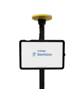
Trimble® SiteVision™ is a high accuracy augmented reality system that is ideal for use outdoors. A lightweight handheld positioning solution, SiteVision works with the Google® Play Services for AR technology or the Apple® ARKit® technology and enables you to interact with your spatial data in the context of the real world. You can visualize and measure positions using GNSS, Electronic Distance Measurement, LiDAR (supported devices only), and Augmented Reality technology as you explore the project site.
The SiteVision system includes:
- The SiteVision app, which is supported on user-supplied devices that are powered by either:
- iOS 13 and later, from iPhone® 6s and later, or iPad® (2017) and later, that is supported by the Apple ARKit technology
- Android™ operating system version 9.0 and later, that is supported by the Google AR technology
- Support for two types of Trimble Catalyst™ antenna connection:
- A Trimble Catalyst DA2 GNSS receiver that connects via Bluetooth. This is supported on Android and iOS devices.
- As part of the SiteVision Integrated Positioning System, the Trimble Catalyst DA1 antenna connects via USB. This is supported on Android devices only.
What do I need to get started with Trimble SiteVision?
Before you start you will need:
- A device that is either:
- Powered by Android 9.0 or later, that is supported by the Google AR technology
- Powered by iOS 13 and later, from the iPhone 6s and iPad (2017) onwards, that is supported by the Apple ARKit technology
- The app downloaded to the device
- A Trimble Identity to be able to log in to the app
- A current subscription
- A model to view. Alternatively, you can create a model in the field or use the sample model included when you install the app.
How do I set up my SiteVision software?
- Go to the Google Play Store or Apple App Store and search for Trimble SiteVision
- Download and install the app
- Run the Trimble SiteVision app on your device
- To get started, accept the End User License Agreement and then enter your Trimble ID username and password
Do I need any special hardware to use SiteVision?
Yes, SiteVision supports two types of Catalyst antenna connections:
- A Trimble Catalyst DA2 GNSS receiver that connects via Bluetooth, supported on both Android and iOS devices:
- The SiteVision Integrated Positioning System, which connects to the Catalyst DA1 antenna via USB. This is supported on Android devices only:
When using the Trimble Catalyst DA2 GNSS receiver, you will need a device that is powered by either iOS 13 or later (iPhone 6s or iPad 2017), or by Android operating system version 9.0 and later, that is supported by the Google AR technology. You will also require the following:
- 1x Pole
- 1x Device Clamp
- Trimble Catalyst DA2 GNSS receiver kit that includes:
- 1x Catalyst DA2 receiver
- 1x 5/8 x 11 pole cap
- 1x Battery pack mount strap
- 1x ANKER PowerCore 5000 Power Bank (5000mAH)
- 1x Sunshade attachment (optional)
When using the Trimble SiteVision Integrated Positioning System, you will need a device powered by the Android operating system version 9.0 and later, that is supported by the Google AR technology. Alongside, the Trimble SiteVision Integrated Positioning System contains the following hardware:
- 1 x Trimble SiteVision Integrated Positioning System
- 1 x USB C to USB C Cable
- 1 x Pole Mounting Bracket
- 1 x Sunshade Attachment
- 2 x Batteries
- 1 x Dual Battery Charger
- 1 x Charging Cable
- 1 x International Adaptor Kit
- 2 x Adhesive Phone Mounts
- 1 x Phone Mount Template
- 1 x Wrist strap
- 1 x Quick Start Guide
- 1 x Shoulder Strap for the Case
To ensure your device is compatible with Trimble SiteVision, please check that your device is on either the Apple ARKit list or the Google AR Technology list.
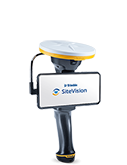
What is the Trimble SiteVision Integrated Positioning System?
The Trimble SiteVision Integrated Positioning system is the Trimble handheld device that integrates the Trimble Catalyst DA1 Antenna (high precision GNSS), with Electronic Distance Measurement (EDM) Laser Rangefinder, and power management.
The power management system provides power to the Trimble Catalyst DA1, the EDM, and your Android mobile phone running the SiteVision application.
How do I set up my SiteVision hardware?
You can follow the instructions in the Getting Started section of the User Guide for the Trimble SiteVision System.
What is Trimble Catalyst?
Trimble Catalyst is a revolutionary GNSS concept delivering positioning-as-a-service to Android and iOS devices. Trimble Catalyst technology is used by SiteVision to obtain high accuracy GNSS positions on your mobile device.
A Trimble SiteVision Universal AR Unlimited subscription includes a Trimble Catalyst for SiteVision Subscription, which includes the precision accuracy level for use with the SiteVision app, access to Trimble Corrections Hub, including Trimble VRS Now™ networks and Trimble RTX™ technology globally, and also supports GNSS corrections from other third party sources. To learn more about Trimble Catalyst, go to the Trimble Catalyst website.
What is GNSS?
GNSS stands for “Global Navigation Satellite System”, which consists of a network of orbiting satellites, ground control stations, and user receivers that allow you to know your location in the world with the push of a button. GPS is the most commonly referenced GNSS constellation; others include GLONASS and Galileo. Refer to the Trimble Catalyst site for more information on the GNSS capabilities.
What is Trimble Connect?
Trimble Connect is a cloud-based data management and collaboration platform that allows you to view, share, and access project information over the Internet from anywhere at any time. Trimble Connect stores the 2D and 3D models, prepared in your office software, that are to be viewed in SiteVision.
The subscription for Trimble Connect Business is included with your SiteVision subscription. If you have separate users who will only be doing data preparation, you can purchase separate standalone subscriptions for Trimble Connect.
To get started with Trimble Connect, go to the Trimble Connect website.
What is Google AR Technology and Apple ARKit Technology?
Google and Apple have developed services for building augmented reality experiences. The service enables your mobile device to sense its environment, understand the world and interact with information.
To learn more about Google AR technology, go to the Google ARCore website.
To learn more about Apple ARKit technology, go to the Apple AR website.
What data plan do you recommend for use with Trimble SiteVision?
When SiteVision is running it uses very little network bandwidth to obtain corrections. The component that uses the most data is downloading the models. We recommend a plan with at least 5GB of data. This will allow for periodic use of SiteVision e.g. one day a week or a couple of hours a day. However, if you are using large models, and multiple downloads of models with your cellular data, we recommend an unlimited plan.
Subscription Management
How many devices can I use my Single User subscription on?
Trimble SiteVision monthly and annual subscriptions are licensed “per user” for use on one device at a time. A subscription cannot be used on multiple devices simultaneously. If you log into SiteVision on a second device, the system will automatically disconnect the services to the first device – so if you left your phone at home, you can borrow a phone and still keep working.
Where can I purchase Trimble SiteVision?
Your Trimble SiteVision subscription can be purchased through any authorized Trimble Distributor. Click GET A DEMO on the Trimble SiteVision website for more information, and to find the nearest Trimble distributor in your area.
What do I get when I purchase Trimble SiteVision?
When you purchase Trimble SiteVision, you will receive a subscription for the Trimble SiteVision application, a Trimble Catalyst for SiteVision subscription, and a Trimble Connect Business license.
How do I cancel or renew my Trimble SiteVision subscription?
Contact your local Trimble Distributor to upgrade, renew, or cancel SiteVision subscriptions.
How do I manage Trimble SiteVision subscriptions for my team?
If you purchase Trimble SiteVision for a group of users, you can assign individual subscriptions to other users in your team, unassign users, or re-assign subscriptions from one user to another user within your team via the License Manager.
What is a Trimble Identity (TID)?
A Trimble ID (or TID) is a unique account identity linked to your email address. You can use your Trimble ID to associate and assign applications, services, and subscriptions from many different parts of Trimble including Trimble SiteVision and Trimble Connect.
To change or modify information on your Trimble ID go to https://login.trimble.com
I already have a Catalyst subscription – can I use this with Trimble SiteVision?
Yes – you will need to purchase a SiteVision Mobile AR Unlimited license, which will allow you to use your separate Catalyst subscription with the SiteVision application.
Please note that the SiteVision Universal AR Unlimited license (which includes the Catalyst subscription), will not allow you to use the Catalyst subscription with other Trimble applications unless you buy a separate Catalyst subscription.
I already have a Trimble Connect Subscription – can I use this with Trimble SiteVision?
No. To log into Trimble SiteVision you must have a Trimble Identity (TID or Trimble Account) with a Trimble SiteVision Subscription.
Performance and Compatibility
Do I need an internet connection to use Trimble SiteVision?
You must have an internet connection to download models from Trimble Connect, and to obtain high accuracy GNSS. You can operate SiteVision without an internet connection but with the following limitations:
- You must have logged into SiteVision on the device previously.
- To use a model (or models) from Trimble Connect, you must have already downloaded it from Trimble Connect while connected to the internet.
- GNSS positioning may not be as accurate, as you will be operating with the satellite-delivered Trimble RTX correction stream or a local SBAS service.
How accurate is Trimble SiteVision?
The accuracy of Trimble SiteVision is dependent on a number of factors, including the type of Catalyst antenna used, the GNSS environment, the length of line being measured to, the type of device being used, and the camera alignment.
Using the Trimble Catalyst DA2 GNSS receiver
GNSS Accuracy:
In areas with VRS Now coverage, where you use a 3rd party VRS service, or when using an Internet Base Station Service (IBSS), the SiteVision system will typically achieve horizontal and vertical accuracies of 1-2 centimeters.
If you are operating in an area that does not have VRS coverage, the Trimble Corrections Hub will select the RTX service. When using the RTX services the horizontal accuracies will vary by location, but are typically 2–10 cm (1–4 inches) in areas with RTX Fast coverage. In areas without RTX Fast, these accuracies can be obtained but may take up to 15mins for full convergence. Vertical accuracies will vary when using the RTX services.
LiDAR:
Some supported SiteVision devices include built-in LiDAR sensors, which can be used to capture measurements. In most outdoor environments the practical range is approximately 5m. For more accurate operations (<20 cm/8 inches), please see the user guide within the Trimble SiteVision application.
SiteVision Integrated Positioning System (Catalyst DA1)
GNSS Accuracy:
In areas with VRS Now coverage, where you use a 3rd party VRS service, or when using an Internet Base Station Service (IBSS), the SiteVision system will typically achieve horizontal and vertical accuracies of a few centimeters.
If you are operating in an area that does not have VRS coverage, the Trimble Corrections Hub will select the RTX service. When using the RTX services the horizontal accuracies will vary by location, but are typically 10–20 cm (4 – 8 inches) in areas with RTX Fast coverage, after convergence, and 30 cm (12 inches) in areas without RTX Fast. Vertical accuracies will vary when using the RTX services.
EDM:
The EDM unit has a range of up to 100 m (300 ft) depending on the target type surface and lighting conditions, but in most outdoor environments the practical range is approximately 25m. For more accurate operations (<20 cm/8 inches), Trimble recommends a range of 0.5 m to 10 m (1.5ft to 30 ft), or up to 25 m (80 ft) to record features requiring lower accuracy (such as trees). For more information download the SiteVision Datasheet, or see the user guide within the Trimble SiteVision application.
What devices are compatible with Trimble SiteVision?
Trimble SiteVision runs on devices that are powered by either:
- iOS 13 and later (iPhone 6s onwards, or iPad 2017), and that is supported by the Apple ARKit technology
- Android operating system version 9.0 and later, that is supported by the Google AR technology
SiteVision and GNSS Technology
What GNSS Satellite Technologies does Trimble SiteVision support?
Trimble SiteVision supports all of the constellations that the supported receivers/antennas track. For a full list of these, please see the Trimble Catalyst Technologies site.
What type of GNSS positions can Trimble SiteVision use?
The SiteVision application displays the type of positioning solution being used under the GNSS menu. These are: Autonomous, RTK Float, RTK Fixed, Differential, RTX, HDRTK, SBAS, RTXCode.
The Trimble Catalyst service monitors the accuracy that your system can achieve from the different signal types and automatically selects and outputs the solution type with best available accuracy.
What is the difference between Source Reference Frame and Target Reference Frame?
A network (for example Trimble VRS Now) will be broadcasting coordinates in relation to a global reference frame such as ITRF2014. This is called a Source Reference Frame.
You might be using Trimble SiteVision with Trimble VRS Now, but want your coordinates in relation to a local reference frame which is commonly used for that region, such as NZGD2000. This is called the Target Reference Frame.
What reference frame are my positions output in?
When using the Trimble Corrections Hub, you must select the Target Reference Frame that matches the reference frame of your model. The SiteVision application will then apply a real-time datum transformation from ITRF (the default reference frame used by Trimble Corrections Services) to the datum you have selected as your Target Reference Frame.
Can I use Trimble SiteVision with local correction sources and Internet Base Stations?
Yes. Local correction sources such as a 3rd party and government VRS or IBSS networks can be used for the Trimble SiteVision System.
To use a local correction source, you will need to deselect Trimble Corrections Hub and enter the required information under GNSS Configuration within the Trimble SiteVision application.
Do I need a separate subscription to Trimble VRS Now to use SiteVision?
No. Your Trimble SiteVision subscription includes bundled access to Trimble VRS Now correction streams where it is available, and worldwide access to Trimble RTX technology.
However, if you are operating outside of a Trimble VRS Now coverage area, you will need a separate local VRS or IBSS delivered correction to achieve optimum results, which may incur additional costs.
I want to use SiteVision indoors, do I need to have GNSS?
No. To use Trimble SiteVision indoors you do not need to have GNSS or be connected to the Trimble Integrated Positioning System (IPS). Please note that the use of SiteVision indoors will not achieve the same accuracies as when used outdoors with high accuracy GNSS.
Can I use QR Markers to align my model indoors?
Yes, Trimble SiteVision supports the Trimble Connect QR Marker extension, and is compatible with the same Markers used by Trimble Connect AR & MR.
For more information, please see the SiteVision user guide.
SiteVision Features
What data formats can I use with SiteVision?
Trimble SiteVision Supports the following open source and industry formats, and Trimble proprietary formats:
Open Source and Industry:
- LandXML (.xml)
- IFC (.ifc/.ifczip)
- Shapefile (.shp)
- Geodatabase (.gdb)
- AutoCAD (.dwg)
- Bentley Systems (.dgn)
- Web Feature Service (.wfs)
- Autodesk Navisworks (.nwc/.nwd)
- Autodesk Revit (.rvt)
- PDF (.pdf)
Trimble Formats:
- TrimBIM (.trb)
- Trimble Business Center (.vcl)
- Trimble Terrain Model (.ttm)
- Trimble Maps (.tmap)
- SketchUp (.skp)
- Tekla (.tekla)
What measurements can I take with SiteVision?
Using Trimble SiteVision you can measure points, grades, areas, and cut/fill values.
The Trimble SiteVision System supports measurements between the real world and the data model using a variety of measurement modes: GNSS, Camera, LiDAR, EDM and AR.
Please note that the EDM measurement mode is only supported when using the SiteVision Integrated Positioning System, and the LiDAR measurement mode is only available on supported devices.
How is my measurement data stored?
All measurements recorded with SiteVision can be synced back to the office via Trimble Connect. Measurements are synced as a .csv file and located alongside the data model which was being viewed in SiteVision. Each time you sync the .csv file it updates the file in Trimble Connect to the latest version of the file on your device. To see an earlier version of the file you can use the History function within Trimble Connect.
How can I place my model on site?
In SiteVision, there are four ways to position a model on site: Automatic, Measured, Manual and Marker.
- Automatic Placement requires high accuracy GNSS, and uses coordinate system information from within model data and/or reads a Trimble site calibration file associated with the model.
- Measured Placement requires high accuracy GNSS, and walks you through steps for completing your own two point calibration, to position a model on site. You can use the IPS standalone, or on the pole mount. This information is recorded and remembered for the next time you open the model to view with SiteVision.
- Manual Placement does not use high accuracy GNSS, and placement is by using gestures on the screen and the augmented reality technology on your field device. Note: Inside you will likely experience model drift. Additionally, your placement will be valid for only that session of SiteVision.
- Marker Placement does not use high accuracy GNSS, and placement relies on a printed QR Marker that is associated with a position within the model. This is useful indoors or in GNSS adverse environments.
What languages are supported?
Trimble SiteVision is available in: English, German, Norwegian, Swedish, Japanese, Chinese, Korean, Dutch, Spanish, Brasilian Portuguese, Russian, Czech, French and Italian.